
The greatest risk of damage due to post-fire flood or erosion events typically follows large and high severity fires. However, the presence of high severity burn sites does not necessarily predict damage from post-fire flood events. Local conditions within watersheds and the nature of precipitation events are important predictors of potential risk. Post-fire assessment teams are instrumental in determining whether infrastructure or resources are at risk of damage due to post-fire events. Where risk is high, fire has removed vegetation cover and created soils that repel water. As a result, more water runs off burned areas generating flash floods, erosion, and destructive debris flows. These events can overwhelm road and dam infrastructure and impact water quality and wildlife habitat. The Southwest is especially vulnerable to post-fire flooding and erosion because fire season is closely followed by a monsoon season, characterized by intense rainfall events. For this reason, rapid response is required to get emergency and flood control measures in place before intense summer thunderstorms occur.
Background
|
|
Erosion is one result of wildfire followed by rainfall. Following the Cerro Grande Fire near Los Alamos, NM, an incised channel was created by erosion within a drainage. Before the rainstorm, the drainage did not have defined banks. The maximum 30 minute rainfall intensity was approximately 0.8 inches/hour. (Photo by John A. Moody) |

|
|
This photo captures rill erosion occurring on a burned hillslope following the Buffalo Creek Fire in Colorado. (Photo by John A. Moody) |

The Las Conchas Fire occurred in New Mexico in 2011 and burned parts of the Santa Fe National Forest, Bandelier National Monument, Santa Clara Pueblo, and Cochiti Pueblo. At the time, it was the largest recorded wildfire in New Mexico. The fire removed significant amounts of vegetation and the soil became water repellant. When an intense rainfall event occurred in the Jemez Mountains in August 2011, the result was large flash floods. Newly implemented flood protection reduced damage in some locations, however there significant debris flows and damage to aquatic ecosystems and infrastructure was observed.

Flash flooding sometimes occurs following wildfires in Southwest watersheds. This photo captures flooding that occurred following the Spring Creek Fire in Colorado. (Photo by John A. Moody)
Runoff from burned areas can alter water quality in multiple ways for the first few years after wildfire up to a decade. Common changes include larger amounts of nutrients like nitrates and sulfates, altered pH, larger amounts of total dissolved solids, increased turbidity, and more organic carbon. Additionally, sediment transport may increase up to 20 times with debris entering reservoirs and lakes that are relied on for drinking water. Together these impacts may affect the color, taste, odor, and treatability of municipal water supplies. Furthermore, regardless of treatments applied to burned watersheds, ash tends to run into stream channels, reducing water quality and potentially obstructing or damaging water treatment facilities.
Post-fire flood events affect nearly all aquatic and riparian insect, fish, and wildlife communities within burned watersheds. Post-fire flooding events and associated ash and nutrient pulses affect water quality and reduce dissolved O2 available to aquatic organisms. These impacts can lead to fish mortality and declines in macroinvertebrates populations, an important source of food for fish species. Inputs of sediment and large flows can reshape stream channels and result in wider and shallower aquatic habitats that are not suitable for many fish and amphibian species. Fine sediments mobilized from burned watersheds also alter spawning substrates of fish species and rearing habitats of aquatic insects. Additionally, large flood events can scour channels and remove entire biotic communities from the substrate. Geomorphic changes, along with a loss of riparian plants that provide shade, can increase stream temperatures and affect the availability of food and thermal refugia, and development rates of fish and amphibian species. Negative impacts to aquatic communities have cascading effects on surrounding terrestrial communities and in particular, riparian consumers such as birds, bats, and rodents.
In burned landscapes, roads and their associated structures are exposed to altered and more variable conditions that can increase the likelihood of infrastructure failure. In many situations, roads designed for unburned conditions cannot accommodate increases in runoff, sediment, or debris following a fire. Threats to roads and structures such as culverts and bridges, include large cut-and-fill failures. Debris that collects at culverts can obstruct runoff passage beneath the road and lead to road failure. Roads and bridges can become washed out by large flows and these transportation corridors can be especially important to access burned landscapes in the emergency response. Other infrastructure, like irrigation networks and hydroelectric facilities can also be impacted by post-fire flooding and erosion. Flows with altered water chemistry can corrode structures and intakes may become clogged with ash or sediment. With large sediment deposition, the capacity of reservoirs generally diminishes and irrigation needs may not be met.
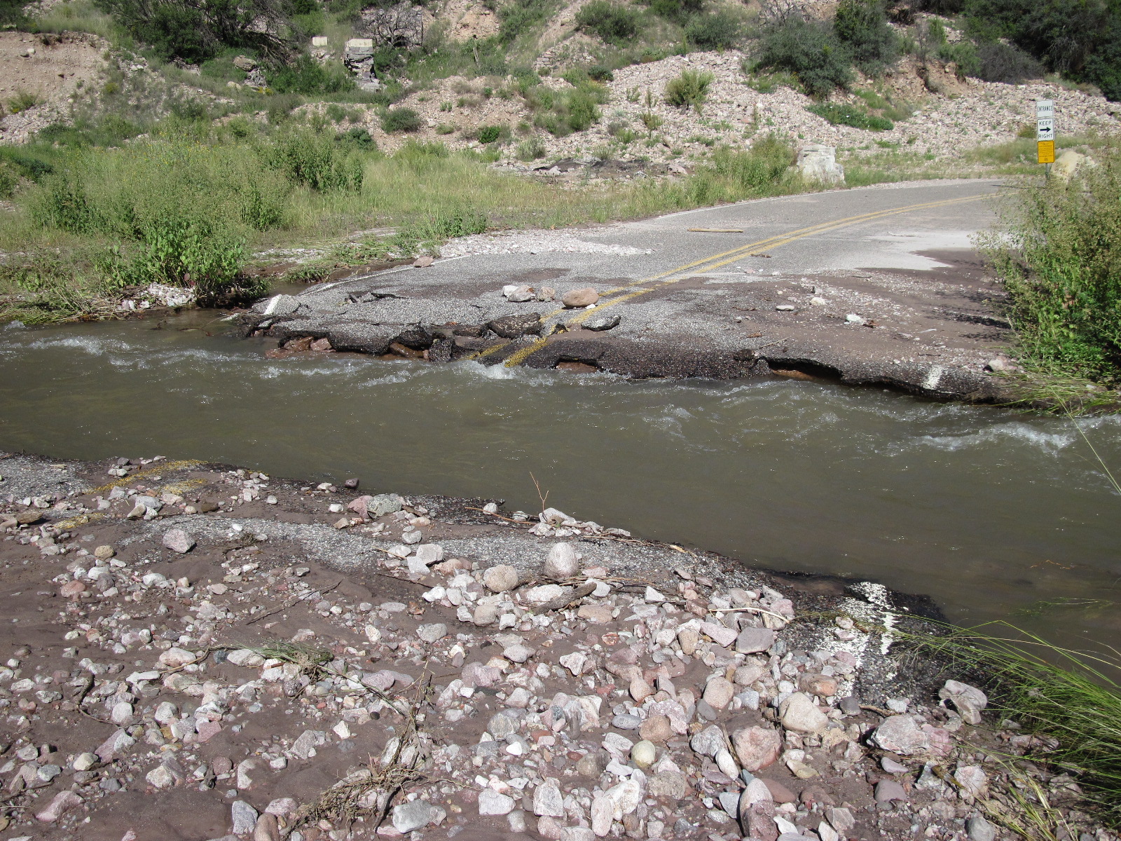
Post-fire flooding causes road wash out after the Whitewater Baldy Fire.
Research into the effects of fire continues to enhance our understanding of how burned watersheds respond to hydrologic events. While some factors, such as precipitation regimes, topography, soil type, geomorphology, or lithology are not inherently tied to fire, these characteristics still tend to control whether a basin generates a post-fire response like flooding or debris flow. Watersheds with rugged morphology, steep slopes, and high gradient streams tend to produce debris flows and hillslope erosion, whereas less rugged basins with gentler channel gradients and smooth hillslopes may produce significant flooding. Studies of Southwestern post-fire landscapes suggest that likelihood of either response depends on patterns of burn severity and subsequent rainfall patterns. Basins that lack extensive burns typically donât experience flooding or produce large amounts of sediment, even after intense summer thunderstorms. See our post-fire library for specific studies and information (library).
Computer models are available and are commonly used for predicting where flooding, debris flows, or erosion are likely to occur within burned watersheds. The results from these models often dictate where post-fire mitigation treatments are implemented. See our list of useful tools.
There is still uncertainty in the science surrounding secondary fire effects and more research, particularly interdisciplinary work, is needed to better understand the causes and effects of post-fire flooding and erosion.
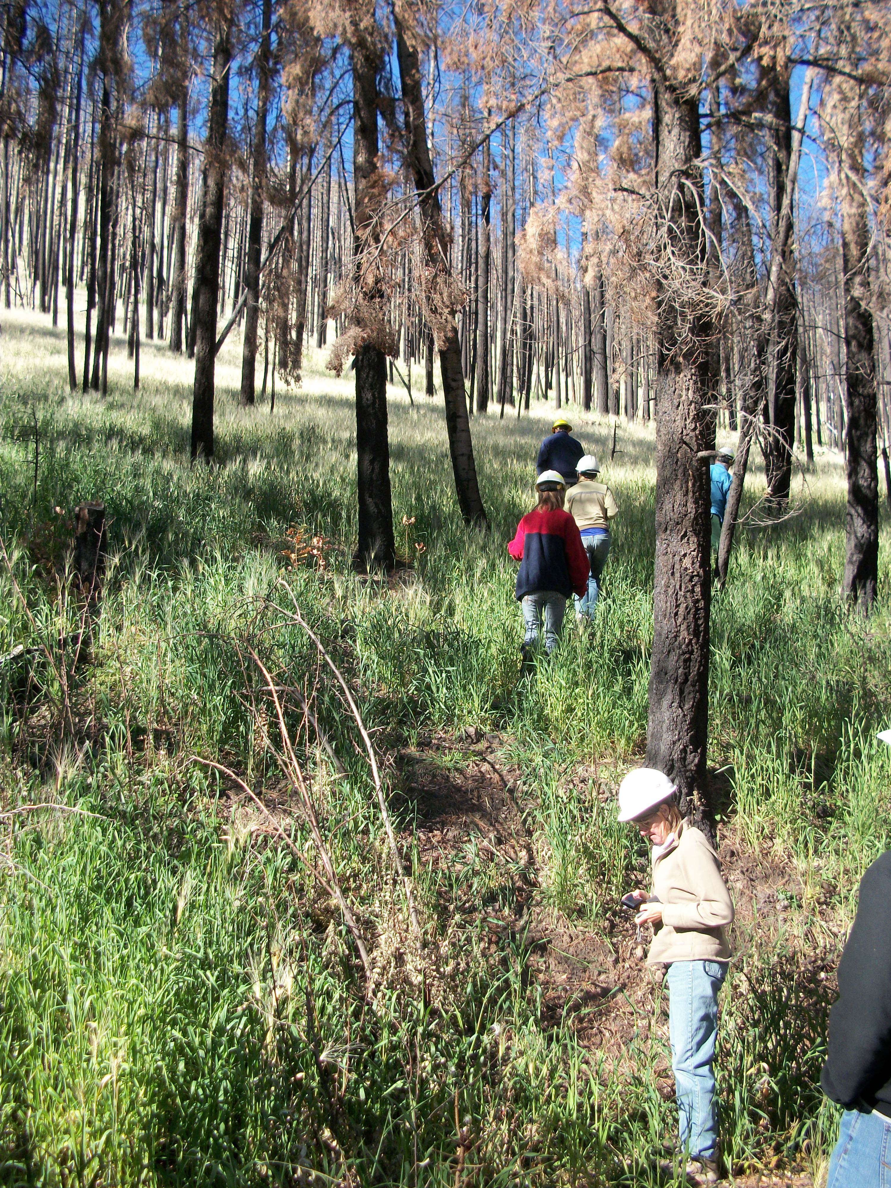
Ecologists measuring results of seeding treatments after the Wallow Fire.
Post-fire flood risks are reduced in many ways. Prevention of flooding and debris flows starts at the top of a watershed, with treatments applied within the burned area. These treatments can include mulching or seeding applied to hillsides to reduce erosion or construction of straw or log dams in channels to slow runoff and trap sediment. Armored stream crossings, upsized culverts, rolling dips, and water bars are methods used to improve the ability of roads and road structures to deal with flooding and sediment. Finally, alert systems can be installed and used to warn downstream communities of flash flooding and debris flows. With advanced notice community leaders, infrastructure operators, and homeowners can mobilize protection measures that ensure safety and reduce damage. More information on specific tools can be found here. For more information on alert systems, click here.
There are some examples of successful mitigation of secondary fire events in several locations throughout the Southwest.
The Silver Fire burned 137,326 acres of the Gila National Forest in New Mexico in 2013, including substantial high and moderate severity burns. This fire left several communities, private properties, and infrastructure at risk from post fire flooding, erosion, and debris flows. Burned Area Emergency Response (BAER) teams assessed conditions on federally owned lands and recommended aerial application of straw and seed to high severity burns. Monitoring of sites with applied treatments revealed that in the first year following fire, seeding and mulching reduced erosion by 147% in mixed conifer sites when compared to untreated sites. Seeded areas in pine sites yielded 103% less erosion compared to untreated sites.